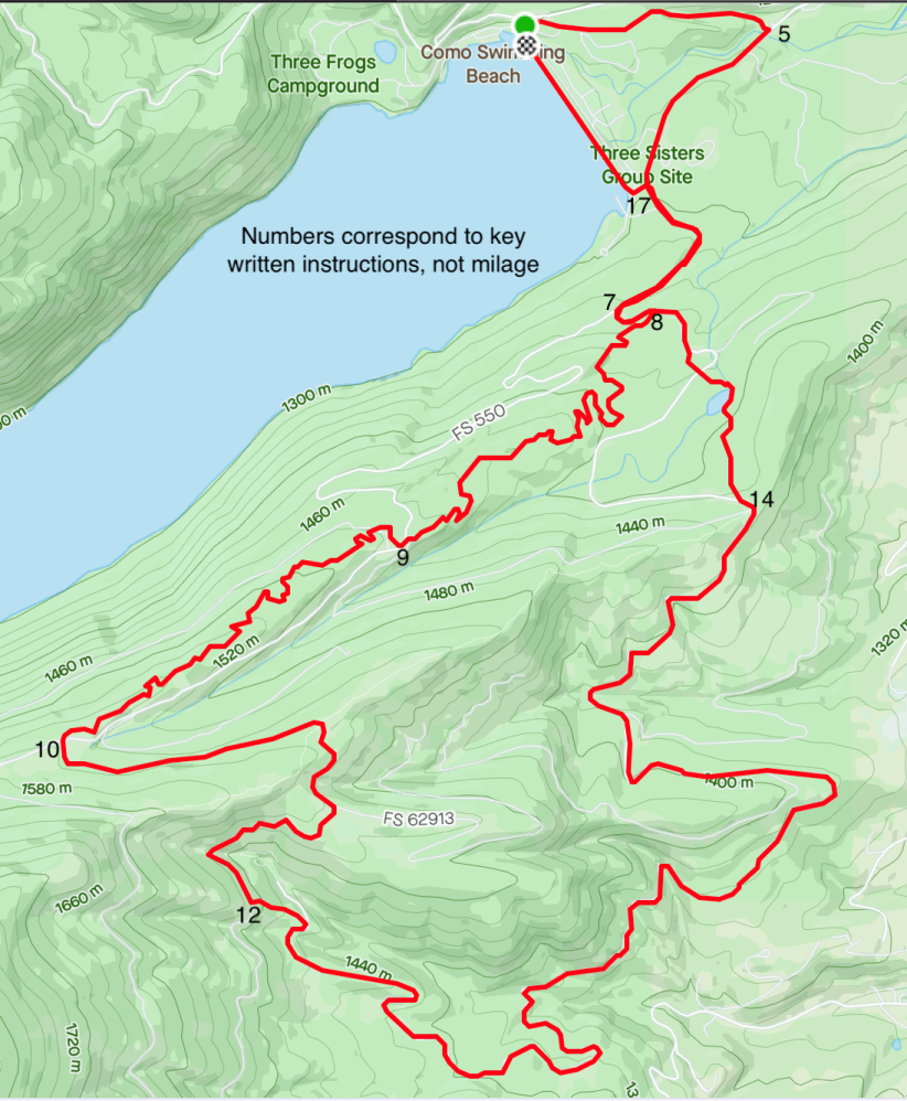
Lake Como Triathlon™ Bike Route Directions
1. Start at Transition Area near metal bridge at dam.
2. Take a right down road towards campground.
3. Veer left onto dirt road heading to gate and boulders
4. Go through and begin single track parallel to campground area. Follow path to paved road.
5. Turn right – begin climb on paved road.
6. Go past boat ramp turn off. Pavement ends – follow 550, Little Rock Creek Road.
7. At intersection 550x550A – turn left on 550A. Continue about 1/4 mile.
8. On right there is rock supported ramp into forest, take this and stay to right at first split. Follow “Kerns Turns” up 1.5 miles.
9. Cross road and continue on upper “Kerns Turns” for another 1.4 miles.
10. Pop out at end of “Kerns Turns” at 13200 Road — go straight (South) – go through gate at about 1/8 mile.
11. Continue upward about ½ mile. Stay on road (do not take single track “Shannon Ridge") and begin rolling descent. Continue approximately ½ mile.
12. On left side look for markings for left-turn onto trail. Go down single track about 200 yards.
13. You will intersect with the 550A Road. Turn right and proceed down fast descent. Will then hit rolling terrain for the next 2-3 miles.
14. Turn right onto single track “Shannon Gulch”; look for markings. This is Northernmost single track. Follow down past Shannon “Lake”.
15. Cross stream. Cross road and remain on single track. Trail splits and take right. Trail intersects road. Turn left on 550A. CAUTION downhill is sand/gravel until you meet paved road.
16. Turn right onto 550 Road.
17. Turn left at LOWER boat-ramp side entrance.
18. Go around gate and right onto dam and cross dam.
19. Finish. (Will have dismount before metal bridge.)